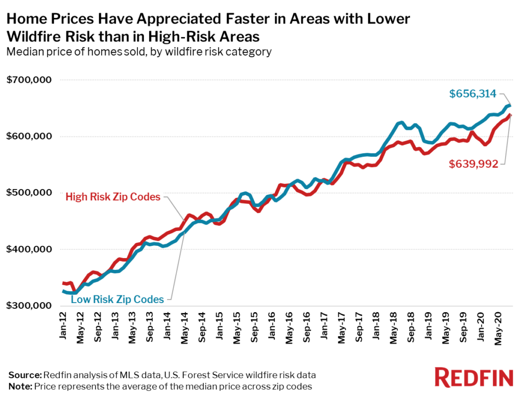
In the past eight years, the price difference between low-risk and high-risk areas has flipped—from a 2.5% premium in high-risk areas in 2012 to a 3.9% discount in 2020—partly due to more intense competition in areas with low wildfire risk.
The median sale price of homes in zip codes with a low wildfire risk has increased 101% since 2012, compared with an 88% increase for homes in high-wildfire-risk zip codes, according to a Redfin analysis of housing market and U.S. Forest Service data across 2,700 zip codes in California, Oregon and Washington. This disparity exacerbates the affordability crisis in low-risk areas, forcing homebuyers who don’t have large budgets to look to more fire-prone regions for affordable homes.
Over the 12 months ending August 2020, homes in high-wildfire-risk zip codes sold for an average of 3.9% less than those in low-risk zip codes—$640,000 compared to $656,000. This is a reversal from eight years earlier. In 2012, homes in high-risk areas sold for an average 2.5% more than in low-risk areas.
Home prices in high-risk areas first dipped below prices in low-risk areas in 2015—three years before the Camp Fire became the most destructive wildfire in California history, destroying over 18,000 structures and killing 85 people.

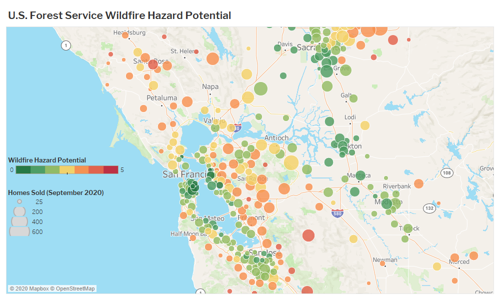
Double-digit price growth in already expensive West Coast cities has likely driven homebuyers to look in more affordable, but fire-prone areas. For example, Bay Area homebuyers who are priced out of San Francisco, where the median home sold for $1.45 million in September, may feel forced into more high-risk areas such as Santa Rosa, where the median price in September was $690,000, or Sacramento, where the median price was $475,000.
“Buyers relocating to Sonoma County from the Bay Area for affordability and quality of life have made up more than 90% of my business since May, when more tech workers started to get permission to work from home permanently,” said local Redfin agent Sandrine Daligault. “One buyer moved from San Francisco to a neighborhood in coastal Sonoma, where he works remotely from a custom home with water views he bought for $1.1 million, unheard of for a home of that caliber in the Bay Area. Another client bought a home in Santa Rosa for $499,000 after selling his East Bay home for $700,000. He’s a police officer who helped fight the Tubbs Fire in 2017, and he’s not worried about wildfires.”
People based in San Francisco make up a significant portion of Sonoma County home searchers: 13.6% of Redfin.com users looking for homes in Sonoma County were from San Francisco in the second quarter of 2020, about on par with 15% in the second quarter of 2019. The net increase in residents was the same during those two time periods, with roughly 440 more Redfin.com home searchers looking to move from San Francisco to Sonoma County than vice versa in the second quarters of both 2019 and 2020.

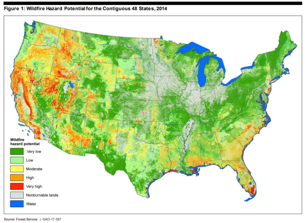
More than 4.5 million homes are located in areas at high risk of wildfire across the states of Washington, Oregon and California, with a total estimated home value of $3.3 trillion.
Homebuying competition is more intense in areas with low wildfire risk than in areas with high wildfire risk. To understand how much more competitive the low-risk areas are, consider that 42% of homes sold in low-risk areas over the past three years went under contract within two weeks, while in high-risk areas, just 33% of homes found buyers as quickly. Similarly, in low-risk areas, 35% of homes sold above list price, compared to 27% in high-risk areas. The tougher competition in low-risk areas makes it harder to buy a home where it’s safer, and gives buyers another reason to shift their home search to risky areas where homes are more affordable and there’s less competition.
September 2017 through August 2020 averages
“The lower cost of housing in wildfire-prone areas compared to low-risk areas is likely just the beginning of the consequences of climate change for the housing market,” said Redfin chief economist Daryl Fairweather. “Right now, wildfires are still a rare occurrence for homeowners, but if fires and other climate disasters continue to happen more and more frequently, some housing markets will go from less desirable to untenable, yet they will remain the only option for many families.”
If the trend of recent years continues and wildfires become even more frequent and destructive migration to high-risk areas could slow. The gap between home prices and competition in high-risk and low-risk areas would continue to widen, making it harder to sell homes in areas with higher risk.
According to Sacramento-area Redfin agent Ellie Hitchcock, a big factor for homeowners and potential homebuyers in areas at risk of wildfire is insurance, which can cost tens of thousands of dollars per year, and is available from only a single insurer. Increasingly, some homeowners in the most risky areas are unable to get insurance at all, which makes financing nearly impossible.
“In some areas that are particularly high risk we’re now seeing the high cost of insurance killing deals and causing buyers to look elsewhere,” said Santa Rosa Redfin agent Molly Stokeld. “One of my clients was going to build his dream home on a high-risk lot in Napa County, but canceled his plans when the only insurance he could find would have cost $17,000 per year.”
“Right now people are still migrating to places that have suffered through wildfires or smoke in the central valley and wine country in California and parts of Oregon because homes in those places seem like a good deal,” explained Fairweather. “Homebuyers often look at the lower sticker price on homes with more fire risk and are driven to buy because it’s what they can afford. Wildfire risk can dramatically increase insurance premiums, droughts can increase water costs and heat can increase cooling costs or make spending time outdoors unbearable. All of these factors can drive homebuyers away from fire-prone areas. Rising home prices in expensive cities also contribute to urban sprawl into high-risk areas. But the long-term costs of building homes in fire-prone areas can be both costly and deadly.”

Note: Only Washington, Oregon and California were analyzed in this study.
We analyzed housing market data for 1,444 zip codes in the states of Washington, Oregon and California with a low risk of wildfires and 1,261 zip codes with a high risk. Wildfire risk was determined using U.S. Forest Service data, which rates the wildfire risk on land from “very low” (1) to “very high” (5). For this analysis we considered zip codes with an average rating of 2.5 or lower to be low risk, and above 2.5 to be high risk. From September 2017 through August 2020, over 2.8 million homes were sold in the 1,444 low-risk zip codes, while 1.7 million homes were sold in high-risk zip codes.


